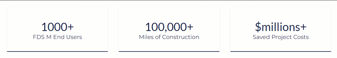
Trusted by 1000's of Companies


FDS is continuously developing first to industry innovative enterprise software's.
- Advance technology for: project developers, project managers, civil and mechanical engineers, environmentalist, permitting people, measurements people, right-of-way agents, field surveyors, survey techs, inspectors, drafters, mappers, designers, operators, compliance people, GIS data mgmt. people, integrity mgmt. people, government regulators, maintenance mgmt. people, administrators, and clerks.
- Advance Ai construction software's built to serve your entire company's wheelhouse from project start-up, to completion, to project lifecycle support.
- Leverage next level efficiency and build more at less costs!
FDS M products support the largest development firms, midstream pipeline companies, utility companies, railroad companies, highway companies, surveying companies, right-of-way companies, environmental companies, construction companies, ENR design firms, and compliance companies world-wide.

| |||
Case Studies & Testimonials

|
|
Simpler start-up to completion processes for automating your construction AutoCAD drawings for any 2D-3D civil and mechanical engineering design construction project. Advance route optimization sheet-mapping technology with project reporting for project lifecycle support. Supports Autodesk C3D.
|
| ROUTE MAPPER BROCHURE |
|
|
Automates your project public or RPLS plat AutoCAD drawings and GIS data management. 2D survey right-of-way management plat software for designing plat drawings faster. Cut 1 plat drawing or cut 100's of plat drawings with line table features set, attribute border set, calculations set, GIS data set, parcel line list, and is simple to learn. Supports Autodesk C3D.
|
| PLAT MAPPER BROCHURE |
|
|
Construction and as-built surveyors field to finish software for quickly auto-drawing your survey AutoCAD models. Includes today's construction and as-built industry standards for codes, and more. Comes with the Survey GIS Mapper tool. Longer stacking distances. Supports Trimble/Autodesk C3D.
|
| SURVEY MAPPER BROCHURE |
|
|
Globally capture, analyze, and edit GIS data faster from your centerline route selection in AutoCAD. Quickly import and edit GIS data, record and analyze GIS data variances, find duplicate and bad data, identify GIS data not tagged, and quality check GIS data with zoom tools. Supports Autodesk C3D.
|
| GEOSPATIAL EDITOR BROCHURE |
|
|
Personal desktop project management program for project lifecycle data management. Includes dashboard business development project reports for faster planning, live analysis, transparent reviews, measurements, daily management, survey data, procurement totals, construction/as-built, and operation communications.
|
|
Paul Reichert, one of the owners and founders of FDS says, "Our innovative engineer mapping products eliminate many project risks, speeds up planning, permitting, construction to as-built processes with full project lifecycle support, and reduces project timelines by over 50% at all vertical levels compared to general practices."
Build more my friends! |